DKRZ NCL unrotate CORDEX EUR-11 rotated data to its origin example#
Example script:
;------------------------------------------------------------
; DKRZ NCL Example: NCL_unrotate_rotated_grid_CORDEX.ncl
;
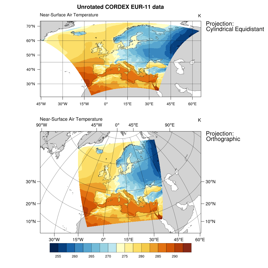
; Description: How to unrotate rotated data to its origin.
;
; - data on a rotated grid
; - two projections: Cylindrical Equidistant and
; Orthographic
; NCL Version: 6.3.0
;
; 04.03.16 meier-fleischer(at)dkrz.de
;------------------------------------------------------------
;-- set global constants
;------------------------------------------------------------
pi = 4.0*atan(1.)
deg2rad = pi/180.
rad2deg = 45./atan(1.)
fillval = -99999.9
;------------------------------------------------------------
;-- Function: unrot_lon(rotlat,rotlon,pollat,pollon)
;-- Description: transform rotated longitude to longitude
;------------------------------------------------------------
undef("unrot_lon")
function unrot_lon( rotlat:numeric, rotlon:numeric, pollat[1]:numeric, pollon[1]:numeric )
local rotlat, rotlon, nrlat, nrlon, nrlat_rank, nrlon_rank, pollon, pollat, \
lon, s1, c1, s2, c2, rlo, rla, i, tmp1, tmp2
begin
lon = fillval
lon@_FillValue = fillval
nrlat = dimsizes(rotlat)
nrlon = dimsizes(rotlon)
nrlat_rank = dimsizes(nrlat)
nrlon_rank = dimsizes(nrlon)
if (any(nrlat .ne. nrlon) .and. (nrlat_rank.ne.1 .or. nrlon_rank.ne.1)) then
print("Function unrot_lon: unrot_lon: rotlat and rotlon dimensions do not match")
return(lon)
end if
if (nrlat_rank.eq.1 .and. nrlon_rank.eq.1) then
rla = conform_dims((/nrlat,nrlon/),rotlat,0) ;-- create 2D latitude array
rlo = conform_dims((/nrlat,nrlon/),rotlon,1) ;-- create 2D longitude array
else
rla = rotlat
rlo = rotlon
end if
rla = rla*deg2rad ;-- convert from degree to radians
rlo = rlo*deg2rad ;-- convert from degree to radians
lon := (/rlo/) ;-- reassign lon
lon@_FillValue=fillval
s1 = sin(pollat*deg2rad)
c1 = cos(pollat*deg2rad)
s2 = sin(pollon*deg2rad)
c2 = cos(pollon*deg2rad)
tmp1 = s2*(-s1*cos(rlo)*cos(rla)+c1*sin(rla))-c2*sin(rlo)*cos(rla)
tmp2 = c2*(-s1*cos(rlo)*cos(rla)+c1*sin(rla))+s2*sin(rlo)*cos(rla)
lon = atan(tmp1/tmp2)*rad2deg
lon@units = "degrees_east"
print("Function unrot_lon: min/max "+sprintf("%8.4f", min(lon(0,:)))+\
" "+sprintf("%8.4f", max(lon(0,:))))
delete([/rlo,rlo,c1,s1,c2,s2,tmp1,tmp2/])
return(lon)
end
;------------------------------------------------------------
;-- Function: unrot_lat(rotlat,rotlon,pollat,pollon)
;-- Description: transform rotated latitude to latitude
;------------------------------------------------------------
undef("unrot_lat")
function unrot_lat( rotlat:numeric, rotlon:numeric, pollat[1]:numeric, pollon[1]:numeric )
local rotlat, rotlon, nrlat, nrlon, nrlat_rank, nrlon_rank, pollon, pollat, \
lat, s1, c1, rlo, rla, i
begin
lat = fillval
lat@_FillValue = fillval
nrlat = dimsizes(rotlat)
nrlon = dimsizes(rotlon)
nrlat_rank = dimsizes(nrlat)
nrlon_rank = dimsizes(nrlon)
if (any(nrlat .ne. nrlon) .and. (nrlat_rank.ne.1 .or. nrlon_rank.ne.1)) then
print("Function unrot_lat: rotlat and rotlon dimensions do not match")
return(lat)
end if
if (nrlat_rank.eq.1 .and. nrlon_rank.eq.1) then
rla = conform_dims((/nrlat,nrlon/),rotlat,0) ;-- create 2D latitude array
rlo = conform_dims((/nrlat,nrlon/),rotlon,1) ;-- create 2D longitude array
else
rla = rotlat
rlo = rotlon
end if
rla = rla*deg2rad ;-- convert from degree to radians
rlo = rlo*deg2rad ;-- convert from degree to radians
lat := (/rla/) ;-- reassign lat
lat@_FillValue=fillval
s1 = sin(pollat*deg2rad)
c1 = cos(pollat*deg2rad)
lat = s1*sin(rla)+c1*cos(rla)*cos(rlo)
lat = asin(lat)*rad2deg
lat@units = "degrees_north"
print("Function unrot_lat: min/max "+sprintf("%8.4f", min(lat(:,0)))+\
" "+sprintf("%8.4f", max(lat(:,0))))
delete([/rlo,rla,c1,s1/])
return(lat)
end
;----------------
;-- MAIN
;----------------
begin
;-- open file and read variables
diri = "./"
fili = "tas_rotated_grid_EUR11.nc"
f = addfile(diri+fili,"r")
var = f->tas
rlat = f->rlat
rlon = f->rlon
rotpole = f->rotated_pole
pollat = rotpole@grid_north_pole_latitude
pollon = rotpole@grid_north_pole_longitude
;-- unrotate the grid and set 2D lat/lons
var@lon2d = unrot_lon(rlat, rlon, pollat, pollon)
var@lat2d = unrot_lat(rlat, rlon, pollat, pollon)
;-- calculate the min and max lat/lons for the map plot
minlat = min(var@lat2d) ;-- retrieve minimum latitude value
minlon = min(var@lon2d) ;-- retrieve maximum latitude value
maxlat = max(var@lat2d) ;-- retrieve minimum longitude value
maxlon = max(var@lon2d) ;-- retrieve maximum longitude value
;-- open a workstation
wks = gsn_open_wks("png","plot_rotated_grid")
;-- set resources
res = True
res@gsnFrame = False ;-- don't advance frame
res@gsnAddCyclic = False ;-- data are not global, don't add lon cyclic point
res@pmTickMarkDisplayMode = "Always" ;-- draw nicer tickmarks
res@mpDataBaseVersion = "MediumRes" ;-- choose map database
res@mpMinLatF = minlat - 1. ;-- set min lat
res@mpMaxLatF = maxlat + 1. ;-- set max lat
res@mpMinLonF = minlon - 1. ;-- set min lon
res@mpMaxLonF = maxlon + 1. ;-- set max lon
res@mpGridAndLimbOn = True ;-- turn on grid lines
res@cnFillOn = True ;-- turn on contour fill
res@cnLinesOn = False ;-- don't draw contour lines
res@cnFillPalette = "BlueYellowRed" ;-- choose color map
res@lbLabelBarOn = True ;-- turn on labelbar
res@tiMainString = "NCL Doc: rotated grid" ;-- title
res@tiMainOffsetYF = -0.025 ;-- move title downward
res@vpWidthF = 0.6 ;-- width of viewport
res@vpHeightF = 0.48 ;-- height of viewport
;-- create the first plot
res@vpXF = 0.12 ;-- start x-position
res@vpYF = 1.02 ;-- start y-Position
plot1 = gsn_csm_contour_map(wks,var(0,0,:,:),res) ;-- use default projection (CE)
;-- create the second plot
delete(res@tiMainString) ;-- we don't need the title twice
res@vpXF = 0.15 ;-- start x-position
res@vpYF = 0.493 ;-- start y-position
res@mpProjection = "Orthographic" ;-- change projection
res@mpCenterLatF = minlat + (maxlat -minlat)/2 ;-- center point of view latitude
res@mpCenterLonF = minlon + (maxlon -minlon)/2 ;-- center point of view longitude
res@mpLimitMode = "LatLon" ;-- map limits mode
res@mpMinLatF = minlat - 1. ;-- set min lat
res@mpMaxLatF = maxlat + 1. ;-- set max lat
res@mpMinLonF = minlon - 1. ;-- set min lon
res@mpMaxLonF = maxlon + 1. ;-- set max lon
res@mpPerimOn = False ;-- don't draw the box around the plot
res@lbOrientation = "vertical" ;-- vertical label bar
res@lbLabelStride = 2
res@lbLabelPosition = "Left" ;-- labelbar labels on left side
res@pmLabelBarOrthogonalPosF = -1.37 ;-- labelbar on the left side
res@tmXTLabelDeltaF = -0.5 ;-- decrease space between ticks and labels
res@tmXBLabelDeltaF = -0.5 ;-- decrease space between ticks and labels
res@tmYLLabelDeltaF = -0.5 ;-- decrease space between ticks and labels
res@tmYRLabelDeltaF = -0.5 ;-- decrease space between ticks and labels
plot2 = gsn_csm_contour_map(wks,var(0,0,:,:),res) ;-- draw second plot
;-- draw text
txres = True
txres@txFontHeightF = 0.016
txres@txJust = "CenterLeft"
gsn_text_ndc(wks,"Projection:", 0.74, 0.91, txres) ;-- next to first plot
gsn_text_ndc(wks,"Cylindrical Equidistant", 0.74, 0.89, txres)
gsn_text_ndc(wks,"Projection:", 0.77, 0.43, txres) ;-- next to second plot
gsn_text_ndc(wks,"Orthographic", 0.77, 0.41, txres)
;-- advance the frame
frame(wks)
end
Result: